


These pages have been dramatically
updated, though mainly behind the scenes so probably not readily
apparent, but now offer better service mainly due to Arduino, Oregon Scientific
and all the brilliant people who figured these things out!! Grazie
ragazzi!!!
Twelve Hour History |
|
 Wind Direction is Averaged over groups of sixteen readings and now with more focused information. Turbulence effects reduced. To see how it was done click here! |
") No need to hunt around, the best style of info made easy. Read this graph in conjunction with the wind direction. The coastal conditions mean the wind changes quickly here. |
") Now using the more reliable Oregon temperature sensors. |
 This is the 12hr relative humidity and when it gets around or below 30% in summer that is real bush fire danger time!! |
Fifteen Day History |
|
 This is a record of the last 15 days of rain. We will also publish daily rain fall on a annual basis as well (updated from time to time). |
") This graph is of the past 15 days of air pressure. 12hour graphs seemed to be too short to show the trends.Thanks Andrew for encouraging me to try this format. |
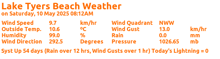
These graphs have been extensively updated with an Arduino and 433Mhz Receiver (in my shed 24/7) intercepting my Oregon Scientific WMR86 Weather Station signals from the four sensor units (reporting Wind Speed, Wind Direction, Temperature, UV and Rainfall from off my roof) with such reliability and versatility, that the handy OS LCD Console can be dedicated to the kitchen bench!!!
I have added my own Air Pressure sensor, Temperature and a Humidity sensor to the Arduino base station as a backup system. I have also built a "Solar Energy" sensor that imitates the data format of the Oregon Scientific sensors and allows the range of sensors to be extended without much alteration to the base station. It is also a very instructive exercise in how to establish robust Manchester Encoding as a data exchange protocol.
The Rain graph now shows the total rain that has fallen in LTB from "Now" back to the last 15 days ago.
My program Arduino system works with the WMR86, or the WMR200 V3.0 type sensors, as they are the same beasts!!!
The engineering in the Oregon Scientific systems is very good and excellent value for price.
East Gippsland Forecasts and Rain Radar |
||
 |
 |
East Gippsland Coastal Forecasts |
 |
 |
 |
The weather has also effected our roads with the Princes Highway between Lakes Entrance and the Lake Tyers Beach turn off having a major upgrade due to water causing subsidence in the road. Check these photos to see what a dip of a few centimeters can mean in civil engineering terms! Fortunately is has been fixed for a few years now.
Rainfall Daily Data: RAIN_DATA
(since June 2016)
The Student Weather Data file: RAW_12HR_DATA
This reporting service does not pretend to be a forecasting page, it just shows as accurately as possible what has happened over the last 12 hours (or 15 days for pressure and rain). You can form you own opinions based on your own local knowledge, for example - what it will be like on the lake or surf after 7hours of a 30km Easterly wind? However if you are looking for a prediction rather than what really happens, try this link WeatherZone
Huw Michael Robert Smith is my Grandson, and I love him so much.